Contact us
Discover how SAR data and space systems can help your organization achieve mission success. Reach out to our experts today.
News Article
A routine basemap isn’t just a better image — it’s the infrastructure that makes change detection, disaster response, and long-term environmental monitoring actually work at scale.
In Part 1 of this series, we explored why national-scale basemap production has been one of Earth observation’s hardest problems. In Part 2, we showed how ICEYE’s SAR constellation has turned that challenge into a routine operation — and argued that the real value isn’t any single image, but the compounding time series that builds with every acquisition cycle.
Now let’s look at what that time series makes possible in practice. The combination of high resolution, consistent collection parameters, and routine revisit unlocks applications that depend on one thing above all: reliable change detection.
When a flood, earthquake, landslide, or volcanic event occurs, the speed and accuracy of the response depends on how quickly you can determine what’s different. A routinely updated basemap gives responders an immediate, pre-calibrated “before” to compare against a post-event image. Because the collection parameters are matched — same orbit geometry, same look angle, same imaging mode — the change detection is clean and fast. There’s no scramble to find a suitable reference image, no manual alignment, no guesswork. The baseline is already there, waiting.
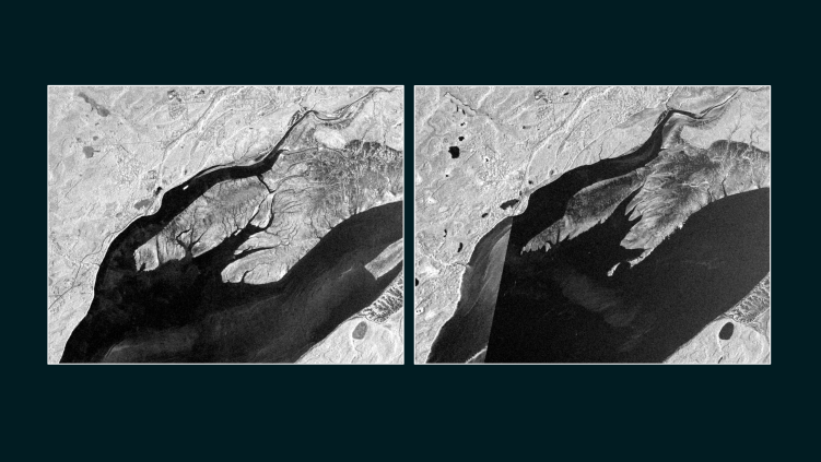
Comparing a flood-event SAR image against the most recent basemap immediately reveals the extent of inundation. In regions like Alaska, where ice jam flooding during spring breakup is an annual hazard affecting vast, remote areas, this turns what was once a reactive scramble into a systematic monitoring operation. The basemap provides consistent, statewide context for every event — season after season, year after year — while the growing time series reveals how flood patterns are shifting over time.
SAR basemaps capture a rich set of topographic features — road networks, rivers, agricultural boundaries, lakes, settlements, and forest patches. When these are collected repeatedly over time, the resulting time series reveals development patterns, infrastructure changes, and environmental shifts such as forest health decline or changes in waterbody levels. This is where the long-term value of routine collection becomes especially clear: the ability to detect gradual change that no single image can show.
Coastlines don’t change dramatically in a single event — they shift gradually, storm by storm, season by season. Tracking that change requires persistent monitoring of entire coastlines with enough resolution and consistency to measure shifts that may amount to only meters per year. A routine SAR basemap program turns coastal monitoring from an occasional survey into a continuous record, capturing both the slow creep of sea-level rise and the acute impacts of major storms.
Along Alaska’s Beaufort Sea coast, erosion rates have doubled — from roughly 6 meters per year in the late 20th century to 14 meters per year in the early 21st — driven by declining sea ice, longer open-water seasons, and warming permafrost. A 32-year cross-mission SAR dataset was the only way to quantify this, precisely because persistent cloud cover and Arctic haze made optical monitoring impractical.
Many landslides occur in terrain that is remote, inaccessible, and rarely observed from the ground. Without repeat satellite coverage, these events can go undetected entirely. Routine basemap collection over large areas of terrain creates the conditions for discovery: when a new image is compared against the established baseline, previously unknown landslides become visible. Over time, this builds a landslide inventory that would be impossible to compile through any other means.
There’s a reason why the gap between mapping capability and mapping need matters more now than ever. The Arctic is changing faster than basemaps can keep up — and much of the change is happening in places where optical sensors are functionally blind.
At Utqiaġvik, Alaska — the northernmost city in the United States — the sun doesn’t rise for more than 65 days each winter. Even during the polar day, low sun angles and persistent summer cloud cover shrink the practical optical imaging window to a matter of weeks. The monitoring need, however, is year-round and accelerating.
Permafrost thaw is destabilizing infrastructure across the state. The Trans-Alaska Pipeline has reported its first slope creep incidents, with support structures tilting measurably over just a few years. Building and road damages from permafrost degradation could cost Alaska $37–51 billion under moderate-to-high warming scenarios. InSAR — a technique that uses the phase information in SAR data to detect millimeter-scale ground deformation — can monitor this subsidence with precision on repeat cycles of days, not years. But only if the data is acquired consistently, regardless of weather and season.
Meanwhile, Arctic shipping routes are opening, coastal erosion is accelerating, and sea ice dynamics are shifting in ways that demand continuous, reliable observation. The monitoring need is growing. The optical imaging window is not. SAR is the only technology that closes that gap.
We’re still in the early chapters of what routine SAR basemap production makes possible. As ICEYE’s constellation continues to grow — and as the archive of basemap time series deepens — the analytical possibilities expand in ways that are difficult to fully anticipate today.
What we do know is that the value of this data is cumulative. Every acquisition cycle adds resolution to the temporal record. Trends that require years of data to detect — the migration of a river channel, the pace of urban expansion into floodplains, the long-term stability of permafrost terrain — are exactly the kinds of insights that a persistent basemap program is uniquely positioned to deliver.
The Alaska demonstration is a proof of concept for what comes next: routine, high-resolution SAR basemaps at national and continental scale, continuously updated, building a living baseline of the Earth’s surface that serves users today and becomes more powerful tomorrow.
The “before” image will always be ready. And it will always be getting better.
→ Part 1: “Why Basemaps Are Still One of Earth Observation’s Hardest Problems”
→ Part 2: “From Decade-Long Ordeal to Routine Operations”
Main Image: Round 1 and 2 detail comparison of shoreline changes revealed through SAR imaging over Alaska 2025.
ICEYE US equips U.S. government agencies, defense contractors, and commercial enterprises with access to timely, reliable, and actionable persistent monitoring. Leveraging the world’s largest constellation of advanced synthetic aperture radar (SAR) satellites, we deliver critical insights—anywhere on Earth, regardless of weather or light conditions.
Driven by innovation and a commitment to national security, ICEYE US is a trusted partner in addressing complex challenges, from disaster response and defense operations to environmental change and scientific discovery. Our state-of-the-art solutions enable decision-makers to act with confidence in safeguarding lives, infrastructure, and assets. Based in the heart of Southern California’s defense-tech innovation hub, ICEYE US is a mission-focused, technology-driven organization, pushing the boundaries of what’s possible in Earth observation.
Learn more at www.iceye.us
Media Contact: Alison Patch, Director of Communications
alison.patch@iceye.usGet the latest news and updates from ICEYE US directly to your email. Don't forget to follow us on LinkedIn. For press inquiries and further materials please refer to our News section.