Contact us
Discover how SAR data and space systems can help your organization achieve mission success. Reach out to our experts today.
News Article
What once took 10 years and $66.3 million to accomplish once, ICEYE’s constellation can now deliver routinely.
In Part 1 of this series, we explored why basemap production has been one of Earth observation’s most persistent challenges: cloud cover that defeats optical sensors across the world’s most critical regions, trade-offs between resolution and revisit that force users to choose between detail and timeliness, and mapping campaigns — like the $66.3 million, 10-year effort to map Alaska with airborne radar — that produce static datasets already aging the day they’re finished.
The question we ended on was: what would it look like if that kind of coverage weren’t a one-time achievement, but a routine operation?
The answer is now operational.
ICEYE US operates the world’s largest commercial SAR constellation — more than 60 satellites launched since 2018. Each satellite is a small, agile spacecraft equipped with a flat-panel phased-array antenna operating at X-Band. That antenna design is key — providing the flexibility to collect imagery across multiple acquisition modes, with spatial resolutions ranging from 25 cm to 27 m and scene extents from 5×5 km up to 200×300 km.
The result is a constellation that can achieve what no single satellite — or small fleet — could before: fine spatial and temporal resolution over large areas, simultaneously. That combination is what makes routine basemap production at national scale a practical reality, not a theoretical capability.
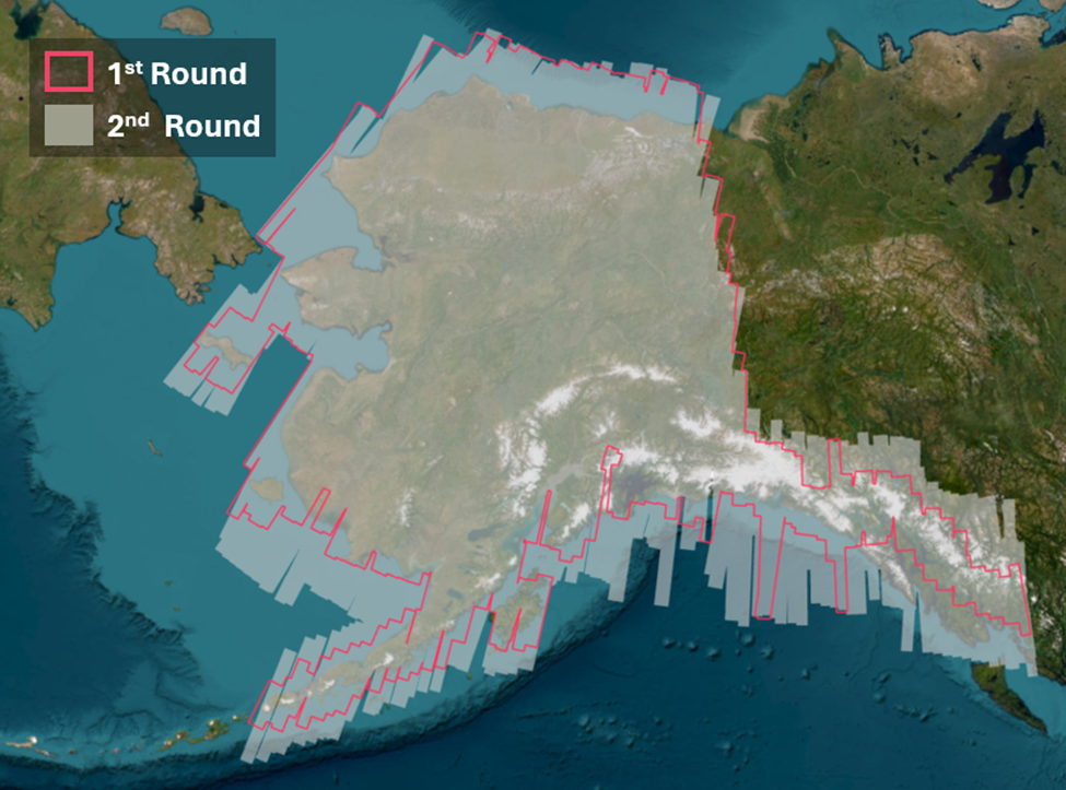
ICEYE US has already put this into practice, mapping the entire state of Alaska with routine, high-resolution SAR coverage. Alaska — spanning more than 1.7 million square kilometers of remote, weather-affected terrain — is exactly the kind of environment where traditional approaches fall short. Cloud cover is persistent, optical windows are narrow, and much of the state is inaccessible on the ground. SAR overcomes all of these constraints, and ICEYE’s constellation does it at a resolution and cadence that enables real operational use.
For the first time, wide-area, high-resolution basemap imaging can be performed routinely using a commercial SAR constellation — overcoming the temporal and spatial limitations that have defined this field for decades.
A single basemap is a snapshot. A growing series of basemaps is intelligence.
This is the distinction that matters most, and the one that’s easy to miss if you think of basemaps as simply a visual product. Yes, a high-resolution SAR basemap is a useful image. But the transformative value emerges when basemap collection becomes routine — because that’s when each new image stops being a standalone deliverable and starts becoming a data point in a time series.
The difference between one-off tasking and routine basemap production is the difference between a photograph and a record. One shows you a place at a moment. The other shows you how that place is changing — and it gets more useful the longer it runs.
With every acquisition cycle, the archive deepens. Seasonal patterns emerge. Anomalies become detectable against an established norm. Slow-moving changes — coastal retreat, urban expansion, shifting river channels — become measurable and quantifiable. The same dataset that supports flood response today is simultaneously building the environmental record that will inform infrastructure planning, climate adaptation, and policy decisions years from now.
In the final part of this series, we’ll look at what regular mapping can mean in practice — from disaster response and flood monitoring to coastal erosion, landslide detection, and the accelerating urgency of Arctic change.
→ Part 1: “Why Basemaps Are Still One of Earth Observation’s Hardest Problems”
→ Part 3: "From Baseline to Action: What Routine SAR Basemaps Make Possible"
Main image: Area mapped by ICEYE US in rounds one and two 2025 state-wide Alaska imaging campaign.
ICEYE US equips U.S. government agencies, defense contractors, and commercial enterprises with access to timely, reliable, and actionable persistent monitoring. Leveraging the world’s largest constellation of advanced synthetic aperture radar (SAR) satellites, we deliver critical insights—anywhere on Earth, regardless of weather or light conditions.
Driven by innovation and a commitment to national security, ICEYE US is a trusted partner in addressing complex challenges, from disaster response and defense operations to environmental change and scientific discovery. Our state-of-the-art solutions enable decision-makers to act with confidence in safeguarding lives, infrastructure, and assets. Based in the heart of Southern California’s defense-tech innovation hub, ICEYE US is a mission-focused, technology-driven organization, pushing the boundaries of what’s possible in Earth observation.
Learn more at www.iceye.us
Media Contact: Alison Patch, Director of Communications
alison.patch@iceye.usGet the latest news and updates from ICEYE US directly to your email. Don't forget to follow us on LinkedIn. For press inquiries and further materials please refer to our News section.